
Robot vacuums have
revolutionized home cleaning by automating a mundane task. Central to their
effectiveness is their ability to map rooms accurately. So, how do robot vacuums map a room? Understanding how
these devices navigate and map areas is key to appreciating their efficiency.
They utilize sophisticated technologies that allow them to understand their
environment, dodge obstacles, and adapt to new spaces. In this blog, we will
explore the technologies and processes that enable robot vacuums to create
accurate maps of your home. From LiDAR and camera-based systems to SLAM
algorithms, each component plays a crucial role in enhancing the cleaning
process. Dive into the mechanics of robot vacuum mapping and see how technology
and practical application come together to keep floors spotless.
What
Is Robot Vacuum Mapping?
Definition
and Purpose
Robot
vacuum mapping refers to the process by which a robot vacuum scans and
understands the layout of a room or an entire floor. This mapping allows the
vacuum to systematically clean the area without redundancy or omission. Mapping
is crucial not only for navigation but also for optimizing cleaning routes,
ensuring coverage, and conserving battery life.
Why Mapping Matters for Cleaning
Efficiency
Efficient cleaning relies heavily on accurate mapping.
A well-mapped room permits the robot vacuum to follow an efficient path,
avoiding areas that have already been cleaned and focusing on neglected spots.
This precision helps conserve resources, saving time and energy. Accurate
mapping means less backtracking and fewer missed zones, leading to a thorough
and efficient cleaning session.
Mapping
Technologies Used
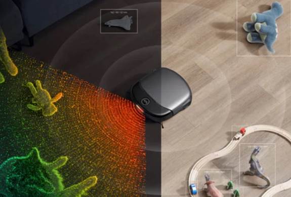
LiDAR:
Spinning Laser Sensors
LiDAR stands for Light
Detection and Ranging. It’s a technology that uses laser light to measure the
distance of objects. In robot vacuums, LiDAR involves a spinning laser mounted
on top of the unit. This sensor emits infrared light and calculates the time it
takes for the light to bounce back after hitting an object. By repeating this
process thousands of times per second, the vacuum creates a 360-degree map of
the room. LiDAR is praised for its accuracy and ability to work in total
darkness, as it doesn’t rely on ambient light for mapping, making it robust and
reliable for creating detailed spatial maps.
Camera-Based Mapping: Visual Landmarks
Some robot vacuums use
cameras for navigation. These models capture images of the room, identifying
visual landmarks and features to create a map. The visual data is processed to
understand and remember the layout. This method mimics how humans visualize and
recall paths, making it intuitive. Camera-based mapping excels in environments
where distinct visual features, such as furniture or wall art, aid navigation.
However, unlike LiDAR, cameras depend on light conditions, which might pose
challenges in low-light settings.
Gyroscope and Accelerometer Methods
Gyroscopes and
accelerometers are used in conjunction to assist with mapping. A gyroscope
measures orientation and angular velocity, while an accelerometer measures
acceleration forces. Together, they help the vacuum understand its movement and
orientation in space. This data assists in tracking the vacuum’s position on an
existing map, ensuring it follows preset paths and returns accurately to its
charging dock. Although not as precise as LiDAR or camera-based maps, this
method supplements other technologies to enhance navigation and path
correction.
How SLAM Works to Localize and Map
Simultaneous Localization and
Mapping Explained
SLAM, which stands for Simultaneous Localization and
Mapping, enables a robot vacuum to build a map of an unknown environment while
keeping track of its location within that map. The process involves
continuously updating a map using sensor data, simultaneously constructing a
spatial model of the environment while pinpointing the vacuum’s current
position. SLAM allows for responsive adjustments, accommodating changes in the
layout without compromising cleaning efficiency.
Correcting Drift with Landmarks or
Camera Waypoints
One of the challenges vacuums face is drift—small
errors that accumulate over time, causing a misalignment between the vacuum’s
perceived and actual location. To counteract this, vacuums use landmarks or
camera waypoints. Landmarks could be fixed points in a room, like a couch leg
or doorframe, which the vacuum recognizes and uses to recalibrate its position.
Similarly, camera waypoints help to reassess and correct the route, ensuring
accuracy over prolonged cleaning cycles.
Steps of Map Building in Robot Vacuums
Initial
Scan and Mapping Run
The process begins with an initial
scan. As the vacuum starts, it performs a comprehensive scan, utilizing its
onboard sensors to gather data about the room’s layout. This includes
identifying walls, furniture, and obstacles. The vacuum inputs this data into
its navigation system to create a rough map. This initial run is crucial,
setting a foundation for the vacuum to understand its cleaning environment and
plan its subsequent paths effectively.
Refining Map Through Repeat Runs
and Updates
Mapping is an iterative process. As
the vacuum continues to clean, it collects more data, refining and updating its
initial map. Each run provides additional information, which helps optimize the
path, improve accuracy, and adapt to changes like new furniture or unexpected
obstacles. Constant updates ensure that the vacuum maintains its efficiency,
dealing promptly with any alterations in the environment.
App and Multi-Floor Mapping Features
How Robots Store and Recall Floor Plans
Modern robot vacuums are often
paired with smartphone applications, allowing users to interact with their
device remotely. These apps store and manage floor plans, giving users the
power to command cleanings from their devices. When moving between floors, the
robot can recall saved maps, knowing each layout in advance. This multi-floor
mapping capability aids thorough cleaning efforts in multi-level homes without
resetting data.
Setting Boundaries, No-Go Zones and
Zones
Apps also provide the functionality
to set boundaries and no-go zones, confining the robot vacuum to specific areas
or barring it from others. Users can draw virtual lines on the app’s map,
instructing the vacuum which areas to avoid, like cord-laden entertainment
centers or sensitive spaces. These features ensure both strategic and safe
cleaning, preventing the vacuum from entanglements or crashes while focusing on
prioritized zones.
Conclusion
Robot
vacuums utilize advanced technology to map environments with remarkable
precision. Using tools like LiDAR, camera systems, and SLAM algorithms, they
efficiently clean homes, navigating around obstacles while learning and
remembering layouts. These innovations not only make cleaning more thorough but
also provide homeowners with greater control and ease of use. Understanding
these technologies highlights the convenience and intelligence of modern
robotic cleaners, showcasing their capacity to adapt and deliver exceptional
results.